![]()
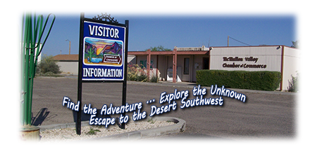
66710 Hwy 60
(PO Box 700)
Salome, Arizona 85348
Phone: (928) 859-3846
Email: mcmullencoc@gmail.com
Providing online information for the communities of the Arizona Outback
since 1997 ... www.AZOutback.net


ATTRACTIONS & ACTIVITIES
Founded in 1865 , the McMullen Valley is perhaps best known for its historic mining areas. All of the important history can be picked up at the McMullen Valley Chamber of Commerce office located in Salome. The McMullen Valley area is home to many outdoor activities, including hiking, recreational mining, boating at Alamo Lake and off-road ATV riding.
Salome ATV club hosts a group ride with a group from Phoenix.
Desert Vistas ... Ghost Towns ... Off-Road Recreation Rockhounding ... Historic Sites ... Old Mines Wildlife ... Golf ... Water Sports & Sunbathing
Whether you are here for one of our special events or a day of shopping or just passing through, the McMullen Valley area truly has something for everyone. We hope you’ll visit and discover McMullen Valley for yourself.
McMullen Valley is full of amazing shops, restaurants and attractions. We have opportunities for everyone.
- McMullen Valley is known for its outdoors and year-around great weather.
- Drop in to one of the many restaurants and cafes to fill your cravings.
- The annual Chili Cook-Off is every year on the 3rd Saturday in February. It attracts hundreds of visitors every year to the activities & food event.
- The McMullen Valley July 4th Celebration attracts 5,000 visitors.
- Dick Wick Hall Days Parade is the 2nd Saturday in Oct and a great community event for all.
Salome Lions Club Complex
The Salome Lions Club operates in Salome, located at 66520 Hall Street.
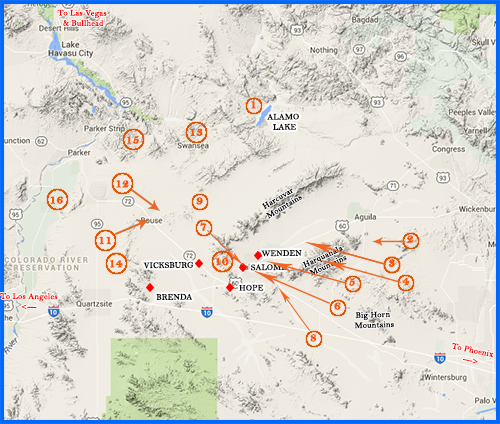

ALAMO LAKE STATE PARK (NEAR WENDEN, AZ)
Alamo Lake State Park is one of the best places to fish for bass in Arizona. The crystal clear lake is surrounded by mountainous terrain speckled with brush, wildflowers and cacti making for a visually pleasing experience.
Nestled in the Bill Williams River Valley away from the hustle and bustle of ever day life, Alamo Lake is one of Arizona’s best kept secrets. Visitors here enjoy outdoor fun, premier bass fishing, rest and relaxation. Fishing tournaments are common at the lake and anglers have an excellent opportunity to catch bluegill, largemouth bass, channel catfish and black crappie.
Spring rains bring an abundance of wildflowers and the lake environment attracts a variety of wildlife year round, including bald and golden eagles, waterfowl, foxes, coyotes, mule deer and wild burrows. Stargazers are sure to enjoy the unbelievable view of the night sky, with the nearest city lights some 40 miles away. Camping is a great way to take advantage of these incredible star viewing opportunities.
There are 80 campground sites with hook-ups to water and electricity. 19 full hook-up sites, developed and undeveloped campgrounds with restrooms and showers. Alamo Lake was created with the completion of Alamo Dam in 1968. Its elevation is 1300 feet. The park is located 47 miles north of Wenden, AZ (off US Route 60) on Alamo Dam Road.
For More Information CLICK HERE

HARQUAHALA MOUNTAINS WILDERNESS AREA
Different from many Sonoran Desert mountain ranges, the Harquahalas (22,880 acres) contain a screened interior canyon system. The distinctive ecosystems provide exceptional natural diversity, including interior chaparrals, desert grasslands and rare cactus populations. The area also supports habitat for desert bighorn sheep, desert tortoise and mule deer populations. Access the northern boundary by jeep trails along Highway 60, east of Wenden. Numerous off-road trails can be found to the south, off Eagle Eye Road. 4-wheel drive vehicles are recommended if you venture off Eagle Eye Road.
For More Information CLICK HERE

HARQUAHALA PACK TRAIL (NEAR SALOME)
The 12 mile trail located near Salome, Arizona. The trail is primarily used for hiking and is accessible from October until April.
The Harquahala Pack Trail was built in the 1920’s to supply the people who lived at the Observatory. Base Camp Trailhead is at an elevation of 2,230 feed, and the Summit Trailhead is at 5,618 feet. It is 5.4 miles from Base Camp to the Summit, with an elevation gain of 3,361 feet. It is rated difficult and not well marked.
For More Information CLICK HERE

HARQUAHALA PEAK SMITHSONIAN SOLAR OBSERVATORY
The Harquahala (originally spelled Harqua Hala) Peak Observatory was at it’s height of glory in 1924. What remains of the field station can be seen first hand by traveling from Eagle Eye Road, up the south side of the mountain, to the peak of the Harquahala Mountains, at an elevation of almost 6,000 feet. In recent years the Bureau of Land Management has refurbished the Observatory and made improvements to the road, as well as adding signs and restrooms at the base of the trail. Even with these improvements, the road is steep and treacherous and it is recommended for high-clearance 4-wheel drive vehicles with experienced drivers only. The panoramic and breathtaking view from southwest Arizona’s highest point, is well worth the trip.
For More Information CLICK HERE
LIGHTHOUSE ON THE DESERT
CULLING’S
(CULLEN’S) WELL
Sometimes known as the "lighthouse in the desert", Cullen's Well was the only stable source of water between Wickenburg and Ehrenberg. There was a light at the top of a pole at the site to guide travelers at night, which is where the name "lighthouse in the desert" came from. Built by Charles C. Cullen, this well was started in the mid 1800's and continued well after Cullen's death in 1878. One story as to the light's origin was that a young man died within shouting distance of the well, and so the light was put up to prevent that from happening again. Today, only part of the well is left.
For More information CLICK HERE

The Great Arizona Outback Rumor and Innuendo Historical Society spearheaded a county-wide effort to clean and restore the Wenden Cemetery. The Master Gardeners of Salome put in watering systems and landscaping. The La Paz County Parks Department donated cement benches and a gazebo was built for shade. An area adjacent to the cemetery was dedicated to the memory of Cactus Kelli, who was the inspiration for the project. A ‘Cactus Kelli Park’ sign was constructed and the VFW Post #3708 donated the solar light for the flag pole. There are 135 plus marked graves and 87 unmarked sites in the cemetery. A number of the ‘oldtimers’ who settled the country are buried at Wenden.
For More Information CLICK HERE

9-11 MEMORIAL MONUMENT, SALOME
The 9-11 Memorial Monument was the culmination of three years of planning on the part of the McMullen Valley Fire District, Salome Lions Club and the McMullen Valley Chamber of Commerce. There were many individual volunteers and local businesses that provided labor, donated materials and made monetary donations to make this memorial possible. The monument was built honoring the victims of the terrorists’ attacks of September 11, 2001. It is the first 9-11 Memorial in La Paz County.
For More Information CLICK HERE

DICK WICK HALL’S HISTORICAL MARKER
& GRAVESITE , SALOME
The founder of Salome is honored with both a historical marker on Highway 60 and Center Street, and the historical gravesite near the site of his old office and home, located at the intersection of Center and Hall Streets.
Dick Wick Hall was a noted humorist, and writer, prospector, and businessman. He not only became "Arizona’s most Famous Humorist" and nationally was compared to Will Rogers and Mark Twain. Locally he was Publisher of the ‘Salome Sun’ 1925 - 1926, owner of the ‘Laughing Gas’ gas station, creator of ‘ The Salome Frog’ and the ‘Greasewood Golf Lynx’, published in the Saturday Evening Post, author of a syndicated column in 28 newspapers from New York to California 1925 – 1926, co-editor of the Wickenburg News-Herald, 1901.
For More Information CLICK HERE

Harrisburg was established in 1886 by Captain Charles Harris, and his partner Governor Frederick Tritle, as a mill town to process ore from the Socorro and other mines in the area. By 1887 two mills were operating here. The post office was established April 29, 1887 and discontinued September 29, 1906. Harrisburg was a ghost town by World War I. It’s not clear, based on historical information, but Harrisburg may have been referred to as Orville, and/or Centennial. There was believed to be 30 people living there with one saloon and one general store and stamp mills.
For More Information CLICK HERE
HARRISBURG CEMETERY, HARRISBURG (near Salome)
The beautiful Pioneer Cemetery of Harrisburg is well maintained and cared for by the local residents. The cemetery is fenced with a large stone monument in the center, which was erected by the La Paz Sheriff’s Posse in December 1985. There are a few headstones standing that are legible. Several small white rock enclosures outlining additional graves, but no names or dates indicating those interred. In total there are approximately 33 interments.
For More Information CLICK HERE

INDIAN SPRINGS - Granite Quarry
This is a popular picnic area in the Harcuvar Mountains, near Tank Pass. This was an old granite quarry, with some of the rock going to the state capital in Phoenix. You can walk around to the southwest to see the quarry. There are still some stones lying around with the drill holes that were used to split the rock. (Contrary to popular belief, this was not an area where prisoners were held.). The road is very sandy and it is recommended that you use a 4-wheel drive vehicle.
For More Information CLICK HERE

The 25,050-acre Harcuvar Mountains Wilderness is in northeast La Paz County 82 miles northwest of Phoenix, Arizona. The Harcuvar Mountains rise abruptly from the desert floor with over 10 miles of its rugged ridgeline within the wilderness. Elevations range from 2,400 feet on the bajadas to over 5,100 feet along parts of the mountainous crest. One of the most important aspects of the Harcuvar Mountains is the major, and southern access route to Alamo Lake State Park approximately 30 miles upriver on the Bill Williams River.
The wilderness area's diverse landforms and plant communities provide habitat for abundant wildlife, including desert bighorn sheep, desert tortoise, cougars, golden eagles, and various hawks.
For More Information CLICK HERE

The Buckskin Mountains are a mountain range in western-central Arizona. The range lies just east of the north-south Colorado River, and south of the east-west, west flowing Bill Williams River. Buckskin Mountain State Park borders the south of the Bill Williams River. The southeast section of the Buckskin Mountains are part of a three-mountain range thrust-faulted system with the Harcuvar and Harquahala Mountains.
For More Information CLICK HERE
Other Regional Attractions
(Clicking on these links below will open a new browser window and navigate to one of the several other county or community website)

Bouse Arizona Assay Office Museum
The Bouse Assay Office. a 25 feet square building, was built about 1902 by the bouse Townsite, Land & Improvement Company and was used as their sales office. It has not been determined when it became the Assay office, however assay services were provided from Bouse for Swansea and other mines up and down the Bill Williams River. After recieving a to restore the building through the Arizona State Parks Board in 1991, the Bouse Chamber of Commerce opened the building to the public as a Museum after the restoration was completed. Many documents and photographs of Early Bouse are housed in the Museum. It also houses a model of Gizmo and other artifacts from Camp Bouse.

Camp Bouse was so extremely top secret, it was not listed with the dozen other training camps and to this day, historian/authors often miss Camp Bouse when writing about the DTC. Troop movement was extremely restricted. During the time it was operational thousands of troops from the 9th Tank Group occupied Camp Bouse. They tested a top secret weapon system mounted on top a tank turret known as the 'Gizmo'. Troops were told it would "change the course of the war."

Of all the ghost towns near Parker, Swansea is the best preserved; with ruins of a large brick smelter, mine, and more than a dozen buildings. Swansea existed for only 15 years before the town disappeared into the desert. The short existence of Swansea ended after WWI when copper prices dropped. By 1937 Swansea was already a ghost town.

Bouse Fisherman Intaglio (near Bouse)
First spotted in 1932, the Bouse Fisherman is an Intaglio also known as a geoglyph or earth figure. These very large earth figures were created many years ago by American Indians. The dark desert pavement stones were removed and the design dug deep into the light colored soil beneath. Thus the figures were preserved for later generations to view.

Poston Relocation Memorial (near Parker)
The Poston or Colorado River Relocation Center was located in La Paz County, Arizona, 12 miles south of the town of Parker. The Poston Memorial Monument (rights) marks the site of the Poston War Relocation Center where 17,867 persons of Japanese ancestry, the majority of whom were United States citizens, were interned during World War II from May 1942 to November 1945. All persons of Japanese descent living on west coast farms, businesses, towns, cities, and states were forcibly evacuated by the United States military on the grounds that they posed a threat to the national security.
Parker Strip and the Colorado River
Why do thousands each year visit this 11-mile stretch of the Colorado River? The Parker Strip is an 11-mile section of the Colorado River between Parker Dam and Headgate Rock Dam in Parker, Arizona…but chances are you already know that. It’s best known for it’s excellent boating, skiing, wakeboarding, and other water related recreational activities. The Parker Strip has been an attraction for generations of weekend warriors and will be for many more to come.


![]()
![]()